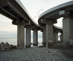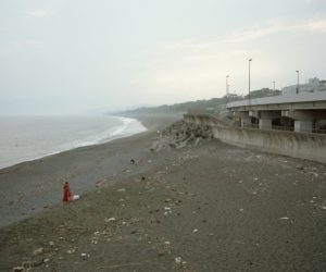
This photo series focuses on the area that extends underneath the Seisho Bypass along the Seisho Coast and National Route 1. The Seisho Coast is usually a quiet place with few people around, familiar to locals as a fishing spot and a walking route for large dogs. At the same time, coastal erosion due to natural processes has progressed. Some areas have lost as much as 45 metres of sand beach in the last 65 years, and the seawater pools at Hiratsuka and Kozu have recently been closed. In the Ninomiya area, a typhoon washed away the beach and caused a section of the Seisho Bypass to collapse in 2007. Currently this area has an artificial sand beach. At Kozu the pier structure of the Seisho Bypass is being eroded by waves, and tetrapods are becoming increasingly common here. I decided to make a photographic record of the appearance of this coastal area that has been restored by humans. Another purpose of this photo series is to make a comparison between Hiroshige’s depiction of Hiratsuka, Oiso and Odawara in “The Fifty-Three Stations of the Tokaido”, and how these three places look nowadays. This series is an ongoing project, which started in September 2018.
“Coastline” brief introduction: Translated by Michael Normoyle and Yoshiko Furuhashi at M&Y Translations (Birmingham, UK)

東海道といえば歌川広重。東海道線の大磯駅に飾られている絵は、保永堂版の「東海道五十三次・大磯」。上の写真は、蔦屋吉蔵版の「東海道五十三次・大磯」と同じように撮ったものです。東海道五十三次は複数の版元からリリースされていて、それぞれ描かれているものが少し異なります。知足美術館刊行の『広重と大正期の写真(Amazon)』には、広重の絵と同じ場所で撮られた大正期の写真が出てきます。当時の機材による制約とはいえ、客観的に風景を捉えているからこそ広重の時代との対比も出来て、約100年後の現代にも意義が出てくるとも思いました。
「Coastline」は、平塚から早川までの相模湾沿い、主に砂浜上を走る国道1号・西湘バイパスの区間で「西湘の海岸浸食と周辺の人々や暮らし」をテーマに、広重の絵との対比も時々含めながら撮り続けていくシリーズです。海岸侵食については、平塚では過去65年間で最大45メートルも砂浜が減少し、二宮海岸では台風で砂浜が消滅して西湘バイパスが崩落、のちに人工砂浜が設けられました。国府津の海岸では西湘バイパスの橋脚が波に浸かり、日々砂浜のメンテナンスが行なわれています。人の手によって修復される風景にも焦点を当てられたらと思います。そして、西湘では「写真撮りに来たの?」と話しかけてもらえることがあるので、地元の方々との一期一会を撮り残すことも出来たらとも思っています。
*昨年5月に発症したメニエール病の影響(眩暈と難聴)は重く、県内を電車移動、東海道線の各駅から徒歩15分圏内で定点観測のように続けられるものとして身体的制約から始めたシリーズです。